
What to Expect When Hiking Mt Whitney's Mountaineers Route
July 20, 2019
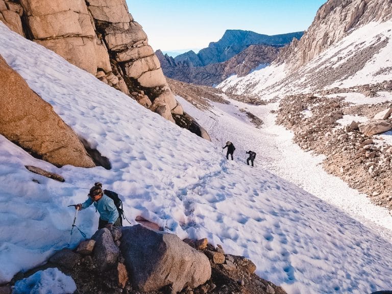
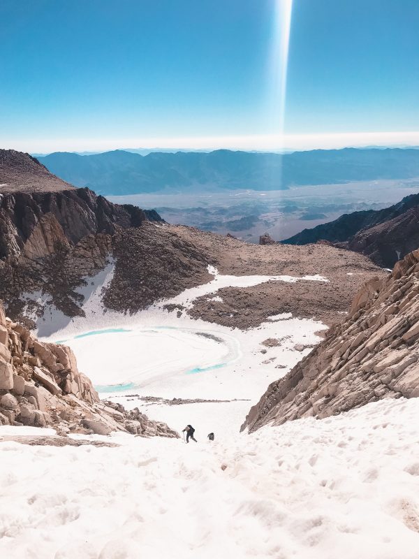
Mountaineers Route July 2019 - photo by Josh Super
What to Expect When Hiking Mt Whitney's Mountaineers Route
It was 2:30 am on July 13th, 2019, when I poured boiling water over the overly priced backpacking meal of scrambled eggs and bacon. I wasn’t hungry. I never am in the morning, but force-feeding calories into my system was a requirement with a 15-hour hiking day in front of us.
As much as I tried to sleep the night before, my mind continuously wandered. What if didn’t make it? Again?
Eleven months earlier, our crew had set out to tackle the same route. We were all confident in our ability to bag the summit. It was August and the routes were clear of snow. Not making the summit didn’t appear to be an option.
But a series of not one, but three unfortunate events led us to turn around at Iceberg Lake. We lost the trail three separate times, leading to late arrival at the Chute with dark, ominous clouds hovering above the summit threatening an afternoon storm while I battled oncoming altitude sickness.
The Mountaineers Route is a more direct, steep, and technical route to the summit of Mt Whitney. It winds over 6100ft in just five miles, less than half the distance of the main Mt Whitney Trail. Unlike the main trail, it requires attention to detail and route-finding skills. There are multiple areas where the trail branches into different routes. Cairns guide the way, but it’s also common for cairns to lead you in the wrong direction. On our first summit attempt, we ended up ascending a giant scree field after following a misguided set of cairns above Lower Boy Scout Lake. Carry a GPS and a pre-downloaded topographic map of the route.
Before we left the trailhead, I took two pills for altitude sickness that was prescribed by my doctor. My body is highly sensitive to altitude, an unfortunate occurrence with my love for mountains. In the previous week, we had bagged Humphreys Peak, the highest peak in Arizona and Boundary Peak, the highest point in Nevada as warmups to Mt Whitney. My altitude sickness usually begins around 12,000ft, as it did on Boundary two days prior to our Whitney climb.
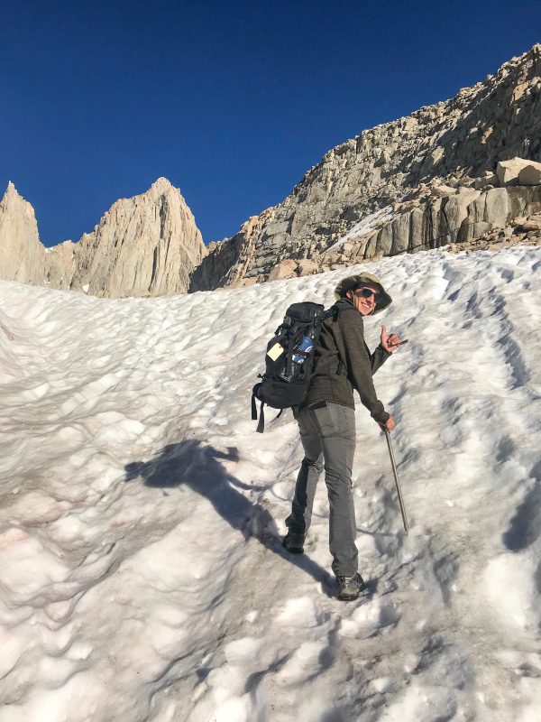
Headlamps guiding our way on the dusty path, our team of four took our first steps toward the summit at 3:15 am. It was mid-July, and although the morning was moderate, a harsh winter clung to the slopes high above us. Following brutal winters, it’s common for snow to cover Mt Whitney’s landscape far into the summer months. In our backpacks, we carried only essentials: crampons, ice axes, extra socks, a plethora of snacks, and our trusty wag-bags obtained from the Mt Whitney Visitors Center.
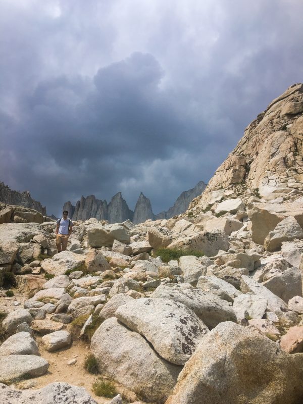
Mountaineers Route Storm - August 2018
Mountaineers Route: The Details
The Mountaineers Route and Mount Whitney Trail follow the same path for the first half-mile until a crooked wooden sign reading “North Fork Trail” appears just before the first big stream crossing. Look to your right, and your headlamp will illuminate a steep dirt path winding into the forest above the Mt Whitney Trail.
The trail is immediately steeper than that of the Mt Whitney Trail. For us, the roar of the river is no longer teasing us but careening down the slope with double the rate of the prior year. We balance our way over partially submerged rocks and a wobbly tree-trunk awkwardly propped between shorelines. Later in the season when snowmelt subsides, the stream crossing will become nothing more than a creek rock-hop.
Darkness hangs heavy during the ascent of this first section. The faint lights of Lone Pine glow from the valley below, the only proof of human existence visible from the mountain. Above, the Milky Way extends across the entire sky. The first section of the trail navigates thick brush and creeks until you reach the Eversbacher Ledges, the first of many trail milestones. In the dark, the short scramble always proves somewhat tricky to navigate — double-check your moves and your path consistently. Here, you’ll be hiking on a narrow rocky outcrop with a steep drop off along the cliffside.
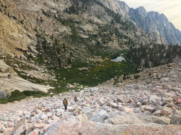
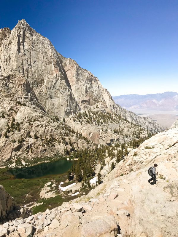
After the Eversbacher Ledges, you’ll arrive at another stream crossing at the mouth of Lower Boy Scout Lake. The trail flattens after the passage as you circle the lake. It’s here our team made our first crucial mistake the year prior. Instead of continuing to rock-hop to meet back up with the river, we veered left up and followed the rockfall until it turned into one of the worst scree-fields ever encountered.
The key between navigating between Lower and Upper Boy Scout Lake is knowing that you want to stay just left of the cascading river. Depending on the time of year, it’s between these two lakes where the sun rises over the distant ridgeline, illuminating the valley below for the first time. It’s also the section where our group encounters a snowfield, the first of many to come.
Even in peak season, the Mountaineers Route is largely void of people. Most of those on the trail take the trip in two days, camping at either Upper Boy Scout or Iceberg Lake. It’s common to see a few tents set up along the shorelines, often blending into the fallen grey boulders. However, you shouldn’t expect to make many trail friends. Although much longer, the less technical Mt Whitney Trail takes up roughly 90% of those looking to bag the summit.
By now, all signs of vegetation disappear, opening the landscape to an endless field of rocky tundra. The peaks of the Sierra’s are prominent, jetting toward the sky in every direction. Just before reaching Upper Boy Scout Lake, the Mountaineers Route veers left up a boulder field. There’s roughly 1,200ft elevation to gain between Upper Boy Scout and Iceberg Lake. In late summer, multiple routes weave in-and-out of rocks; all eventually leading to the same spot. When snow lingers, a clear trekking path paves the way in a direct route at the base of a north-facing cliff line.
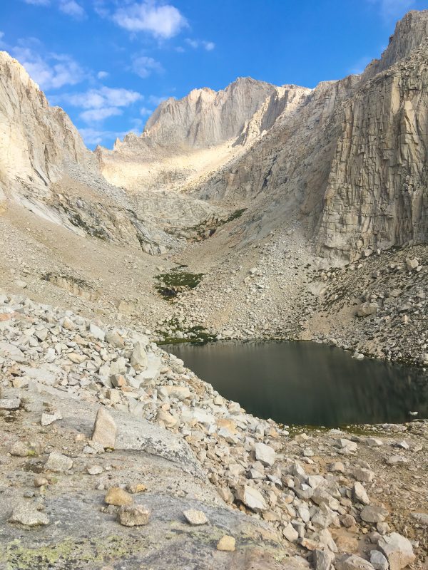
It’s here the Mt Whitney spire begins to dominate the landscape. It’s so close you can nearly touch it; however, over two thousand feet remain between Iceberg Lake and the summit of Mt Whitney.
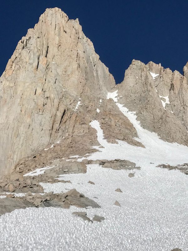
It’s quite apparent that the “walk in the park” is over once you reach Iceberg Lake. Above you stands the two most prominent features of the Mountaineers Route: The Chute and The Final 400. Now, depending on the season, these two sections provide entirely different challenges.
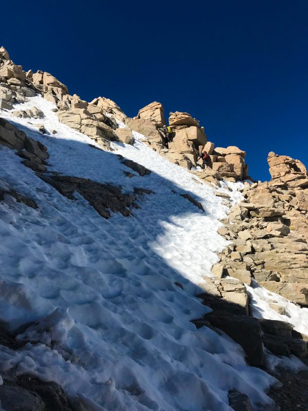
The Chute - July 2019
Winter on Mountaineers Route
When snow remains present, as it did in our July 2019 summit, it can either be a blessing or a curse on the Chute. Ice axes and crampons are required, and you should brush up your skills on how to self-arrest in an emergency. The Chute is steep, but it can be easier to climb when snow is present as you’ll be avoiding loose scree. Slow and steady is critical on the 50 degree slope, along with ensuring you begin on the Chute as early as possible to prevent post-holing and slipping down off soft snow.
Once you reach the Notch (a flat section on top of the Chute), you’ll have two summit options: the Final 400 or the “Easy Walk-Off.” However, there’s a catch. The “Easy Walk Off” is only easy without the presence of snow. With snow, it becomes more dangerous than the Final 400 as a slip could result in a thousand-foot slide if you don’t properly self-arrest.
The Final 400 will also have present snow and ice. The trick here is understanding your comfort zone and defining your route. Without snow, the Final 400 is considered a class 3 rock scramble up a 65-degree slope. If snow is present, the class 3 section will most likely be coated in a thick layer of ice. However, there are multiple ascent options up the Final 400. Choose to navigate within your comfort zone. We chose to hug the left side of the funnel, where the route was dry but had a few class 4 moves and v0 boulder problem. Our group assisted each other to ensure a safe summit. Go slow, be smart, and help your mates.
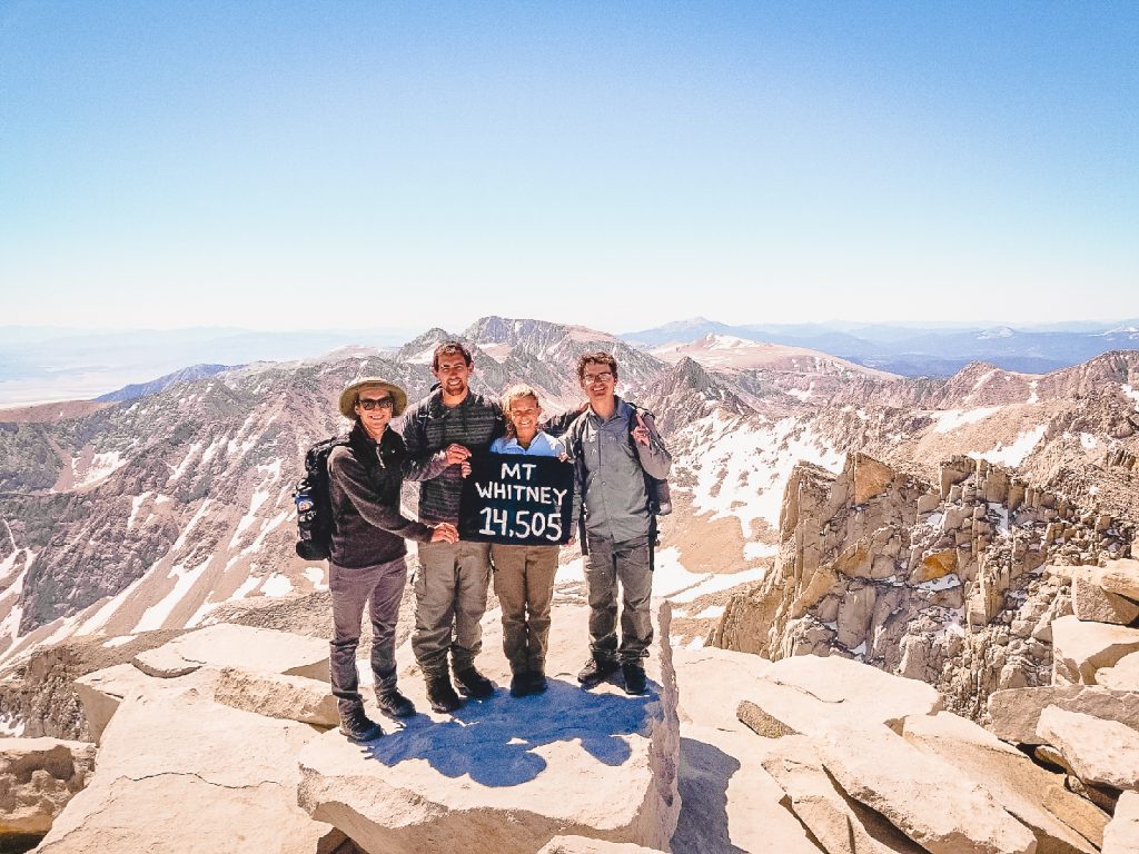
From there, you top out directly next to the hut at the summit. Congrats!
Note: I worried about the Final 400 — a lot. I’m not a super confident rock climber and steep scrambles have been known to push a specific fear of heights. The “Easy Walk-Off” was in awful condition and not really an option. However, the 400-foot scramble was fun. For anyone psyching themselves out, picture it as a giant adult playground.
Final 400 - July 2019
Summer on Mountaineers Route
Late summer brings lightened loads (no ice axe, no crampons) and requires no snow mountaineering. However, the Chute is filled with loose boulders, rocks, and scree. In the summer, a helmet is recommended as it’s possible a rock can come loose from a climber above. Those who have climbed the Mountaineers Route in the summer recommend staying to the left side of the Chute.
At the Notch, you can choose to summit via the Class 3 scramble up the Final 400, or the “Easy Walk-Off.” The “Easy Walk Off” is considered a Class 2 the follows the ridgeline past the Notch to the backside of the mountain and eventually meets up with the Mt Whitney Trail. The walk-off takes around fifteen minutes longer than the Final 400 but proves an easy summit option for those uncomfortable with the scramble.
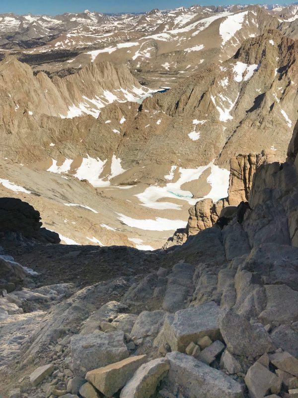
Descending via the Mt Whitney Trail - July 2019
Detailed Trail Time for July 13th Summit via Mountaineers Route
Leave trailhead: 3:15 am
Arrive Upper Boy Scout Lake: 6:15 am
Arrive Iceberg Lake: 7:30 am
Summit: 10:00am
Mountaineers Route Vs. Mt Whitney Trail
The summit of Mt Whitney is only the halfway point, or for us, less than the halfway point. You can choose to descend back down the Mountaineers Route or the main Mt Whitney Trail. We descended via the Mt Whitney trail for a change of scenery, and because we didn’t have proper rappel equipment to safely descend the Final 400 with ice present.
In our descent, I noted some distinctions between the two routes, the biggest being how LONG Mt Whitney Trail is compared to the Mountaineers Route. If you’re susceptible to altitude sickness, the Mt Whitney Trail hovers above 12,000ft for multiple miles. Besides the 99 switchbacks, most of the trail is a gradual increase and even descends in certain areas. The Mountaineers Route is steep, direct, and doesn’t require many unnecessary maneuvers. After summiting via such an efficient route, the never-ending Mt Whitney Trail taunted our minds again and again.
That being said, the Mt Whitney Trail is stunning, with incredible lakes, valleys, waterfalls, and wildlife. It’s also an easy-to-follow trail that makes the summit of Mt Whitney accessible for those not comfortable with technical routes. It's also important to note that BOTH trails require a Mt Whitney permit.
Each trail has perks, but I prefer the Mountaineers Route. If you plan to summit via the Mt Whitney Trail in a single day, prepare to start early and finish late merely due to the mileage.
If you’re preparing to conquer the tallest mountain in the 48, the Whitney Zone and Mt Whitney Facebook Group are helpful resources to keep up to date with current climbing conditions.
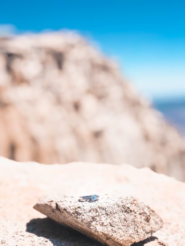
And if the summit wasn't sweet enough, Mt Whitney became a spot with extra meaning to my heart after Josh proposed at the summit. What a day!

At any given moment, Shalee is either lost, hunting for ice cream, or obsessively planning her next adventure.
Born and raised in rural Michigan, she began exploring the shores of Great Lakes as a teen, often sleeping in her car to save money. Eventually, her urge to explore pushed beyond her Midwest borders. Today, Shalee shares her tips and stories to thousands of readers interested in adventure, outdoor, and sustainable tourism. Her pack now includes two spunky hiking cats and her partner, Josh. Learn more about her here.
Join the Adventure
")


Absolutely wonderful writeup! I was lucky to summit Mt. Whitney via the Main Whitney Trail in 2017 and 2018, and the Mountainous Route is on my bucket list. Also, it looks like you all made fantastic time – under 7 hours to reach the summit via Mountainous Route! Congratulations! Also, congratulations on your engagement! Best wishes!
Thank you! It was a wonderful route and I’m so happy everything fell into place. Mt Whitney is a beautiful mountain!
maybe I have not looked deep enough yet- where do I find trail details for boundary peak?
Here’s a good resource: https://www.theoutbound.com/yosemite/hiking/hike-boundary-peak
We parked at Queen Mine and the road was pretty rough but passable. Some websites say the trail is hard to follow but there’s a pretty clear path right up until the last 1000ft which is more of a light scramble. Only four of us on the trail the entire day!
Congratulations on your engagement! I know summiting Mount Whitney was on your bucket list. Happy for you!
#ShaleeWanders
Congrats on your engagement, Shalee. Josh is a lucky man. Thanks for a another great post on another item on my bucket list.
I Want To Hike Mount Whitney! But I Don’t Have Much Experience. I’ve Hiked Up To Gilbert Lake From Onion Valley Campground. I Hiked It Pretty Easy Fast Paced.
Any References To A Group To Hike This Mountain With!?